Rawala Kot
source : (google.com.pk/wikipedia)
Rawalakot is a town in Pakistan Administered Azad Kashmir, and is the district headquarters of Poonch Division and Poonch District.
Location
Rawalakot is located at Latitude 33°51'32.18"N, Longitude 73° 45'34.93"E and an Elevation of 5374 feet. Rawalakot is approximately 76 kilometres (47 mi) from Kohala, and about 120 km (75 mi) from the city of Rawalpindi. It is linked with Rawalpindi and Islamabad via Goyain Nala and Tain roads. Via Kotli Satiyan and Kahuta.It is also linked with Rawalpindi via Sudhnuti.
A view of Mong Road, Rawalakot
A view of city from height
Transport
Travel routes
Construction of the Ghazi-i-Millat road (also known as Guoien Nulla road ) between Rawalakot and Azad Pattan has considerably reduced travel times, it is main road which is connecting Islamabad/Rawalpindi with Rawalakot city. A bus across the LOC, the Poonch-Rawalakot bus has helped to re-establish ties across the border.
Ghazi-i-Millat road
Ghazi-i-Millat road
Road links
The road passing through Jalooth-Paniola connects Rawalakot to Bagh and Muzaffarabad. The other road that passes through Mohri Farman Shah, Shuja Abad is the shortest possible road link that connects Rawalakot city with Bagh. Murree, Islamabad and Rawalpindi are in a southward direction from Rawalakot. The town has another road link with Kotli.
Rawalakot Airport is non-operational, as there is no demand for the air service provided by Pakistan International Airlines. The airport has been closed since 1998.
Climate
Rawalakot features a subtropical highland climate (Cwa) under the Köppen climate classification due to high altitude. Rawalakot has mild to warm temperatures during the spring and autumn, humid temperatures during summer and cold to snowy during the winter. The temperature can rise as high as 38 °C (100 °F) during the mid-summer months and drop below −3 °C (27 °F) during the winter months. Snowfall can occur in December and January, while most rainfall occurs during the monsoon season stretching from July to September.
Economy
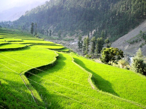
Subsistence level farming for corn and wheat is conducted in and around Rawalakot. Some level of vegetable farming including tomatoes and Spinach are grown as well. The largest industry for Rawalakot is the harvesting of Poplar trees, which are harvested and transported to Pakistan for manufacture of sporting goods.
Wheat Crop at Rawalakot.
Wheat Crop at Rawalakot.
Tomatto Crop at Rawalakot.
Government employment is a major sector for employment, however, a large section of the population is dependent upon remittances from over seas workers who send money to their relative in Azad Kashmir.
Due to lack of opportunity, most citizens of Poonch, including Rawalakot are looking for ways to get employment in other countries. Moreover, it is not uncommon for qualified youth from the city to find employment in larger cities like Rawalpindi/Islamabad and Peshawar.
Demography
Rawalakot and its surrounding areas have a population of over 500,000. Its population includes overwhelming majority of SADOZAI Sudhans, And Awans And then Rajpoot (Bhatti)'s Khawajgan (Mir,Butt), , Abbasis, Kianis, Sheikh's, Syeds Gardezis,MUGHAL (Douli,Mirza, Maldial, Baig,chughtai & Hotil or HOTI largest Mughal tribe in BANGUIN , Dar and many others. There is also a significant number of people from other regions who live in Rawalakot for sake of employment in the government sector.
Rawalakot-Poonch Trade Route & Bus Service
Pakistan and India agreed to facilitate travel between the two parts of disputed Jammu and Kashmir by providing entry permits to divided Kashmiri families to travel across the Line of Control (LOC). Thousands of divided families are living on either side of the LOC since 1948 after a cease fire line was drawn which divides Kashmir between Azad Kashmir and Indian Kashmir. The cease fire line was turned into the Line of Control (LOC) after the Simla Agreement between India and Pakistan in 1972. Both countries started bus services between the two Kashmirs in April 2005 for families to reunite and truck service in October 2008, for businesses to flourish. The Poonch-Rawalakot bus service was started on 20 June 2006 through Tatrinote and Chakan Da Bagh point. A total of 87 persons on first day crossed the Chakan Da Bagh point on foot after coming on board the two buses on either side.
Communications
Two privately owned cable television systems are available in Rawalakot, which carry Pakistani and international television programs. In addition, A local FM radio station named Voice of Kashmir FM 105 is also functioning in the area. This radio station is part of a network of three radio channels. The other two channels are VOK FM 105.6 (Bagh) and VOK FM 105.4 (Muzaffarabad). Cell phone services are also available in this region. They include major cell phone operators: Zong, Mobilink, Ufone, Warid Pakistan, Telenor and SCOM. PTCL Wireless telephone service is also available here. SCO-the local phone company is operated by This telecom provider is responsible to provide landline telephone network with minority shares of other operators. All major mobile phone companies operating in Pakistan provide service in Rawalakot. Broadband internet access is available from DSL. WiFi hotspots are also available to a very limited areas that include some parts of Rawalakot city, Dehra & Kharick.
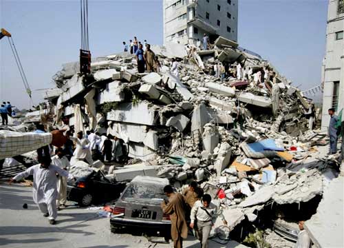
2005 Kashmir earthquake
2005 earthquake relief in Rawalakot. Cuban Field Hospital.
On Saturday, October 8, 2005 a 7.6 magnitude earthquake killed 73,338 people and left up to three million homeless in Pakistan, including Azad Kashmir. The city of Rawalakot, the capital of the Poonch, suffered significant damage from the 2005 Kashmir earthquake; although most of the buildings were left standing, many of them were rendered uninhabitable, and some of the population was left homeless. Most of the buildings have been reconstructed.
Education
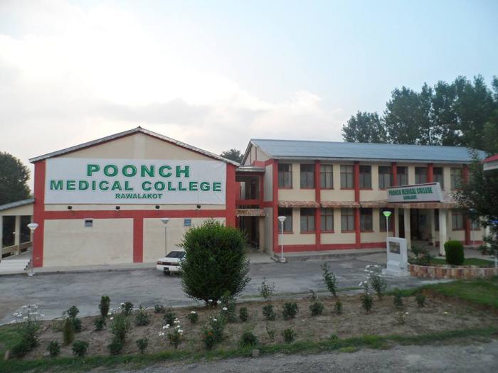
In addition to the Agriculture University of Azad Kashmir, Rawalakot has a medical school ; Poonch Medical College, a Government College for men and women, numerous higher secondary schools/high schools, and a number of private schools. During the earthquake of October 8, 2005, many degree colleges were badly damaged. Most have been rebuilt so for.
Poonch Medical College Rawalakot
Poonch Medical College Rawalakot
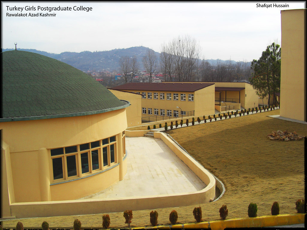
Rawalakot Turkey College for Girls
The Rawalakot Turkey College for Girls has been established in Rawalakot to replace the Post-Graduate College for Girls, located at Kharick, which faced severe destruction in the October 2005 earthquake.
Through a joint organization of IHLAS Media Holding of Germany and DITIB (Religious Affairs of Turkish Islamic Union Germany), the Government of Turkey took on the task for the construction of Rawalakot Post-Graduate Girls College with the Earthquake Relief and Rehabilitation Authority. The reconstruction effort was later joined by the Turkish Islamic Union of Netherlands, which participated through donations of Basic Health Unit facilities to the said school.
The design, construction, decoration and landscaping of the school have been carried out by Turcon Private Limited. A geological survey of the land led to the decision of construction limited to two floors. In a campus-wise set-up, all the buildings have been scattered in a 240,000-square-foot (22,000 m2) area. The educational facilities include 30 classrooms, five laboratories, a gymnasium, hostel, lodging for teachers, principal’s house, BHU, mosque, multipurpose hall, and an administration block. A total of 14 buildings exceeding a covered area of 60,000 square feet (5,600 m2) have been built for the school. Basic amenities such as computers, television sets, music system, sofa sets, beds, mattresses and blankets for teachers and students have been arranged for with the help of donors. Thousands of trees and flowers have also been planted for landscaping.
Construction was done using conventional methods. Both ends of the buildings have been strengthened through shear walls, providing an earthquake-proof structure to ensure safety of the children. The materials used in construction are the same as in the developed countries.
Lightweight insulated shingle roof material has been imported and used for the first time in Pakistan for added comfort. Well-insulated U-PVC type windows have also been used.
Rawalakot Turkey College for Girls
Culture
Rawalakot has no theatres; however, the university does have some cultural events.
Media
Daily Dharti Rawalakot is an Urdu language news paper published from Rawalakot.[Monthly Join Hands] is also published from Rawalakot. Daily newspapers from Pakistan are available in English as well as Urdu. Voice of[6] Kashmir FM 105 Rawalakot. Icon Network Cable Television and Satellite Television Service is widely available. Parhari writers include Muhammad Sagheer Khan, Liaqet Laiq and Hameed Kamran. a Pakistani TV drama director Nadeem Siddique and Sheeraz Kashmiri Author and Journalist also belongs to Rawalakot
Tourism
Banjosa and Toli pir two popular tourism destination in Azad Kashmir are in this .
Toli pir Rawalakot
Toli Pir is basically a hilltop locale located in Tehsil Rawalakot in the Poonch District of Azad Kashmir. It is situated at an elevation of about 8800 feet above sea level. It is approximately 40 kilometers, or a 45 minute drive, from Rawalakot in Azad Kashmir. One can view Abbaspur, Bagh and Poonch River from Toli Pir.
Toli Pir is the highest mountainous location in the northeastern part of Rawalakot, it is the spot of origin of three diverse mountain ridges. The tourist rest house on the way to Toli Pir is also located in a picturesque site. There are some remains of an aged tomb on the top.
Banjosa Lake is located near Rawalakot in Azad Kashmir. An artificial lake at an altitude of 1981 meters, a manmade land because of its beautiful and amazing views and fabulous garden, is very famous tourist spot with lively trees and colorful flowers. Facilitated with swings and slides the spot is an attraction for kids as well. Banjosa Lake is surrounded by mountains and lush green garden abundant with flowers and trees, this is a very beautiful small lake.
Banjosa Lake Toli pir Rawalakot
Banjosa Lake Toli pir Rawalakot
Toli pir Rawalakot
Toli pir Rawalakot
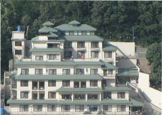
Lodges
government-owned and private guest houses, and hotels are available in different parts of Rawalakot. Attractions include: mountain-based adventure tourism, rock climbing, mountaineering, trekking, summer camping and hiking, water-based adventure tourism, and paragliding.
government-owned Lodges Rawalakot
Private Guest Houe Rawlakot
Private Guest Houe Rawlakot
Private Guest Houe Rawlakot
Private Guest Houe Rawlakot
Rawalakot Airport
Airpo Rawalakot Airport is situated in Chak Dhamni has great attraction for tourist.
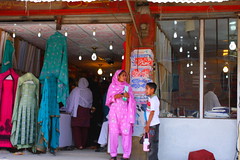
Shopping
Rawalakot has a downtown area, which consists of shops selling everything from groceries to electronic goods.
Shopping At Rawalakot
Shopping At Rawalakot
Shopping At Rawalakot